
ITC analysis of satellite images
- The individual tree crown approach applied to IKONOS images of a coniferous plantation area
- Individual tree crown delineation on Ikonos and QuickBird imagery: the Cockburn Island study.
- Specialized forest inventory from an IKONOS image
- ITC species classification and regrouping with an IKONOS image
Individual tree crown delineation on Ikonos and QuickBird imagery: the Cockburn Island study.
Done in collaboration with:
- CLC-Camint Inc.,
- R & B Cormier Inc.,
- Ontario Forest Research Inst., and
- CFS Sault Ste. Marie.
Abstract
For forestry applications with high spatial resolution (< 1 m/pixel) imagery, an Individual Tree Crown (ITC) approach is generally preferable to pixel-based analyses. This paper presents preliminary results of ITC delineations using a valley following approach over Cockburn Island (Lake Huron, Ontario), first with an Ikonos image (100 cm/pixel), then with a QuickBird image (70 cm/pixel), to examine some of the benefits of the added spatial resolution. Six test areas, typically containing only one situation (i.e., big or small trees, deciduous or coniferous), were analysed on both images. For reference, local maxima (or Tree Top) analyses were also performed and are shown for both media. As expected, the results favour QuickBird with gains in areas of trees with narrow crown (less omission errors), better separation of tree clusters and finer delineation of crown boundaries. In general, the QuickBird image analysis produced 50% more tree crowns and is in closer agreement with its Tree Top counts. Fro m visual inspection, it is obvious that a significant number of tree clusters remain.
This work is part of a larger proof of concept project, done in collaboration with forestry and forest inventory companies, that intends to check if an ITC approach can lead to better forest management maps. The project will evaluate the automatic creation of forest stand polygons, their species composition (up to 10 species) and parameters such as stem density and crown closure, as well as, the synergistic effects of using a large scale photography (LSP) sampling strategy for volume estimation.
Reference
Gougeon, F.; Cormier, R.; Labrecque, P.; Cole, B.; Pitt, D.; Leckie, D. 2003. Individual Tree Crown (ITC) Delineation on Ikonos and QuickBird Imagery: the Cockburn Island Study. In 25rd Canadian Symposium on Remote Sensing / 11ème Congrès de l'Association québécoise de télédétection, Montréal (Québec), Canada, Oct. 14-17, 2003.
Test sites for ITC and TT Counts
Figure 1. Locations of the six test sites on part of the QuickBird image of Cockburn Island, Ontario. Site contents vary from medium size crown deciduous trees (Sites 1&2), to small crown coniferous trees (Sites 5&6), to very small regenerating coniferous trees (Site 4), with a mixedwood area (Site 3).
Results
| Site 1 | Site 2 | Site 3 | Site 4 | Site 5 | Site 6 | All sites | |
|---|---|---|---|---|---|---|---|
| QB_ITCs | 1,322 | 1,268 | 1,303 | 1,480 | 1,560 | 1,570 | 8,503 |
| QB_TTs | 1,398 | 1,304 | 1,283 | 1,520 | 1,550 | 1,524 | 8,579 |
| IKO_ITCs | 865 | 846 | 897 | 942 | 1,022 | 1,026 | 5,598 |
| IKO_TTs | 1,046 | 1,009 | 1,013 | 1,219 | 1,135 | 1,192 | 6,614 |
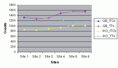
Figure 2. Tree counts from six sites on the QuickBird (QB) and Ikonos (IKO) images procured with the ITC and the local maxima (or TreeTop) approaches. Site contents vary from medium size crown deciduous trees (Sites 1&2), to small crown coniferous trees (Sites 5&6), to very small regenerating coniferous trees (Site 4), with a mixedwood area (Site 3).
Conclusions (from paper)
This paper summarily compared Ikonos and Quickbird panchromatic imagery for their individual tree crown delineation (and tree counting) capabilities in various forest conditions as an initial step towards their evaluation for the semi-automatic production of forest management inventories that are hopefully more precise, accurate and timely than their conventional photointerpreted counterparts. QuickBird s added spatial resolution appears to detect more trees, less tree clusters and provide better crown boundaries. It may be detecting smaller codominant trees, and even intermediate trees, that Ikonos is not. How will that influence the precision of information at the forest stand level? Will the added spatial resolution of the multispetral imagery help with ITC species classification? Will the final results of the project, ITC cover maps grounded by LSP plots from both Ikonos and Quickbird, be better than conventional forest management maps? At this point, we still have more questions than answers
Project status
- On-going